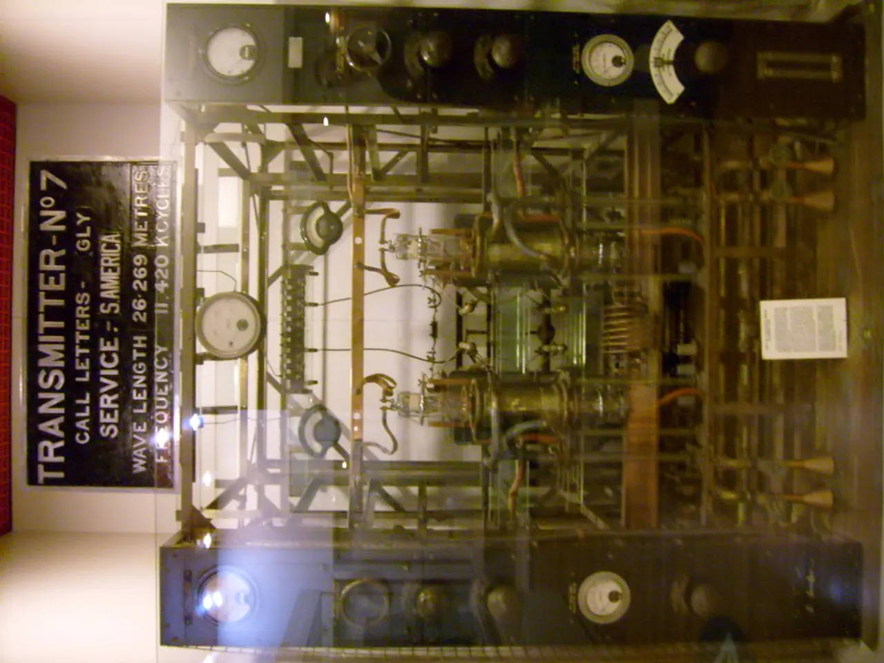
Distance Measuring Equipment (DME) refers to equipment that calculates and communicates the distance between an aircraft and a ground station or another aircraft.
Distance Measuring Equipment (DME) is a crucial tool in aviation navigation, providing precise distance measurements between aircraft and ground stations. Defined by EUROCONTROL, DME works by sending pulse signals from the aircraft to a ground station, which then responds with answer pulses. The system calculates the distance based on the time delay between sent and received pulses.
DME operates in the 960 to 1215 MHz frequency band, using pulse pairs for interrogation and response between airborne and ground units. There are two main types of ground DME stations: Low-Power DMEs (LPDME) and High-Power DMEs (HPDME). LPDMEs transmit about 100 watts and are typically used for approach navigation paired with Instrument Landing Systems (ILS). On the other hand, HPDMEs transmit around 1,000 watts and are usually co-located with VHF Omnidirectional Range (VOR) stations for en-route navigation across airways.
Modern avionics, such as Garmin’s latest products, allow pilots to tune up to two separate DME frequencies and integrate slant-range data into flight decks and displays, supporting advanced techniques like DME/DME Area Navigation (RNAV), where distance from multiple DME stations can provide position fixes without reliance on GPS.
On navigation maps and charts, the symbol of a DME device is square. When the pilot chooses the VOR frequency, he automatically chooses the DME frequency (VOR/DME). In case the marker cannot be established, a DME device can be installed together with the Glide Slope device to provide distance information for the runway.
In ILS systems, the DME device is placed in the Glide Path (GP) station. DME devices provide distance information between the aircraft and the ground station/beacon. They can also provide groundspeed and time-to-station readouts by differentiation.
It's worth noting that DME is often used with VOR and ILS systems for direction and distance information. However, DME, as defined by EUROCONTROL, is not explicitly stated to be used with these systems for direction and distance information. Similarly, while DME can provide distance information from the start of the runway for some non-precision approach procedures such as VOR approach, it is not explicitly stated to be used for this purpose in all cases.
In summary, DME is a complementary navigation tool that provides precise distance measurement between aircraft and ground stations, critical for both en-route and approach navigation phases of flight. Its symbol on navigation maps and charts is easily recognisable, and its integration with modern avionics offers advanced navigation capabilities.
Technology plays a significant role in aviation navigation, as evidenced by the use of Distance Measuring Equipment (DME). Modern avionics, such as Garmin's latest products, utilize DME for integrating slant-range data into flight decks and displays, facilitating advanced navigation techniques like DME/DME Area Navigation (RNAV).


%20refers%20to%20equipment%20that%20calculates%20and%20communicates%20the%20distance%20between%20an%20aircraft%20and%20a%20ground%20station%20or%20another%20aircraft.)